|
|
|
The Town Historian collects and organizes local history materials and cooperates with other public officials in the preservation of historically valuable Town records. The Town Historian researches, writes, and makes public presentations on aspects of Town history, serving as a resource to the community.
The Town Historian serves as an advocate for the preservation of the Town's historical sites, maintaining records that document the built environment of the community.
Town Historian Term Information - appointed annually in January David Carman Appointed January 4, 2016
David work full-time and corresponds via email @ Send correspondence to: Link to Livingston County Historian Page - to the left is a “Search Records” option http://www.co.livingston.state.ny.us/historian.php
Groveland has a rich history dating back to the early days of the country. Below are some of the more noteworthy events. Some information is personal interpretation but interesting nonetheless. |
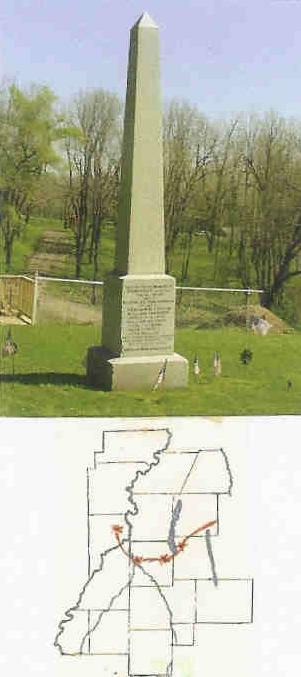
Ambuscade MonumentAs of October 1, 2009 has been officially added to the National Register of Historic Places from NYS Office of Parks and Historic Preservation. With effort from Larry Turner who pushed to have this be recognized as one of the battle places of the 1779 Sullivan Campaign.
THE GROVELAND AMBUSCADE OF THE
REVOLUTIONARY WAR IN LIVINGSTON COUNTY
1779
Information provided below has been the work of Larry Turner and Bill Koschara and a brochure filed at the Groveland Town Clerk’s office:
A BRIEF CHRONOLOGY OF THE PARK
THE AMBUSH THAT SAVED MANY LIVES On the western front of the Revolutionary war the British and Indians carried out a campaign of annihilation against the farms and settlements in New York and Pennsylvania. Under instructions from Congress, George Washington sent General Sullivan to destroy the Indian economy and throw them wholly on the British for support.
Few people are aware that the farthest west Revolutionary Battle in New York State was here in Livingston County.
The Groveland Ambuscade resulted in the death of Indian guide Han Yost and the loss of 16 of General Sullivan’s men at Groveland and the torture death of Lt. Thomas Boyd and Michael Parker at Little Beard’s Town (near Cuylerville).
How did that save lives you may ask?
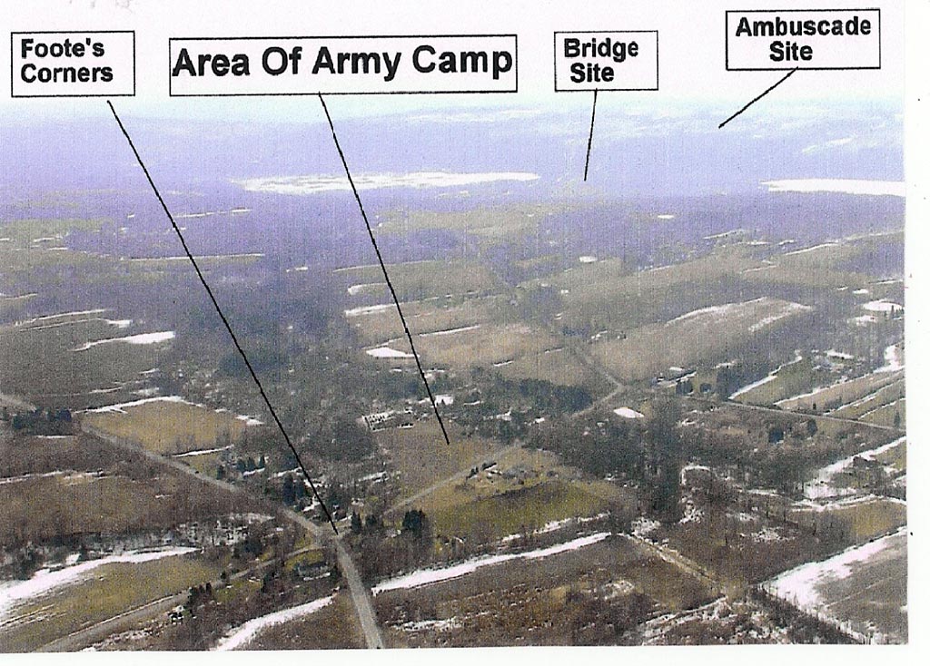
Consider the situation. Major-General John Sullivan and General Clinton had encamped their army of near 3000 on the high ground east of Conesus Lake while their engineers prepared a road across the swamp and a bridge across the inlet. ( While a man on foot could use the Indian paths a pack horse would break through and an army would turn it into a quagmire ).
The location of British Colonel Butler and Indian Chief Brant with their under 1000 men was not known. Neither was the exact location of their headquarters at the Indian town of Chinese Castle or Little Beard’s Town.
Meanwhile Butler and Brant had set up an ambush in the ravines and forests near the top of the slope west of Conesus Lake. They would have the superior position and element of surprise. The ambush location was over three miles from the army's encampment and about 1/2 mile from the construction site. If the battle became too intense they would have easy retreat to the Genesee valley. From here they watched the army's activities.
The lay of the land and the army's habit of following the Indian trails predicted the probable path Sullivan and Clinton would follow.
Unlike the Newtown battle, Sullivan no longer had his heavy cannon and would not be set up in a standard battlefield array because of the swamp and narrow roadway and bridge.
The night of Sept 12, 1779, General Sullivan ordered Lt. Thomas Boyd to lead a party of 3 or 4 to find Little Beards Town the Seneca Castle. The party grew to about 25 mainly Morgans riflemen.
The scouts passed the enemy lines undetected. Neither side was aware of the other’s presence.
The scouts arrived before dawn at the deserted Gathtsegwarohare village. In the morning they encountered several Indians, killing one, and rested there part of the morning. Boyd then sent two runners who reported to General Sullivan that the scouts were returning.
Lt. Boyd later sent two more runners to report that the scouts would wait on the trail for the army. These men soon returned reporting they had seen Indians on the trail. The scouts started in pursuit of the Indians who were seen from time to time. Their guide HanYost warned it was a trap but the scouts continued the pursuit.
Now on September 13, 1779, comes Boyd's returning scouting party approaching Butler and Brant from the rear. Were they a lone party or were there others? If they got back to Sullivan, the ambush might be revealed. The scouts were decoyed by the Indians right into the ambush.
A fierce deadly battle ensued inflicting over twice the patriot casualties that had occurred at the better known battle of Newtown. Boyd and Parker were captured and taken to Little Beard’s Town where their mutilated remains were found the next day. Eight of the scouting party, including Timothy Murphy, escaped the ambush and reported to Sullivan who had become concerned over their delay. Gen. Hand’s light brigade responded but it was too late.
Butler and Brant, their battle plan exposed, retreated and the potential of a major battle was averted – probably saving many lives on both sides. Some say saving the army a capital blow.
The army continued on its mission virtually unopposed.
An Historical Note: Boyd and Parker’s remains were discovered by Paul Sanborn. Moses Van Campen also a member of Morgans Riflemen was in charge of their burial. Both men later settled in western NY. Van Campen’s final resting place is in Until The Day Dawn Cemetery, Angelica, NY. Paul Sanborn settled near Conesus and often brought visitors to the ambuscade site telling its tale. Sanborn’s final resting place is in Union Cemetery, on Rt. 256, 2.1 miles north of Scottsburg (location #10 on the tour map).
WGK 9/4/07
The Men in Sullivans Army were so greatly impressed by the 22 inch long ears of corn, the fine vegetable gardens and the fruit orchards that many determined to return and settle on this land after the war,
Three such men are:
These three soldiers are buried in the Lakeview Cemetery above the Ambuscade Park. There may be more soldiers who returned here to settle but we don't have the information to prove it.
In 2006, new research led us to the fact that Hanyerry was not the Oneida Indian Guide killed at the Ambuscade in 1779. It was his brother, Lt. Han Yost. Hanyerry died in 1795 according to his family histories.
We have newly attached a plaque to the monument, “Oneida Indian Lt. Han Yost, Thaosagwat, was killed at this site on Sept. 13, 1779 while acting as a guide for Lt. Boyd’s Scouting Party. His brothers name Hanyerry was mistakenly placed on the monument”.
TOUR GUIDE USING THIS MAP (on file at Town Clerks office) Start at the park in the Village of Conesus on NY Route 15, 0.7 mi. north of the intersection with County Road 33 (Sliker Hill Road). The log house which is staffed seasonally by the GA-NE-A-SOS History Keepers has local history displays.
Proceed north on NY 15, to Footes Corners. A Stone Monument is in the intersection with Footes Corners Road on your left and a State Historical Marker is on your right. The monument has a bronze relief map of the entire Sullivan Campaign. Sullivan’s army was encamped in this area.
Turn left onto Footes Corners Road to Clark Road. Turn left onto Clark Rd. Proceed to stop sign and continue straight onto Henderson Hill Road (all season gravel) to East Lake Road (County Road 8). At the foot of the hill Turn left onto East Lake Road to Sliker Hill Road (County Road 33).
Turn right on Sliker Hill Road across the swamp lands to the bridge near the intersection with NY Rt. 256 - 3.4 miles from the army camp.
Early settlers reported the log remains of the army bridge near this site. From the area of the bridge, you can see the formidable barrier the west side of the valley presented with a steep climb of over 200 feet to where Butler and Brant planned the ambush.
Turn right on NY Route 256. David Gray Hill Road goes up the hill on the left. (This is a seasonal limited use steep gravel road. David Gray Road leads directly to the entrance of the Ambuscade Park but it is not recommended for general use.) Sullivans’ scouts may have used this route. Continue north on NY Rt. 256 and turn left onto Maple Beach Road. Follow Maple Beach Road to Barber Hill Road. Turn left onto Barber Hill Road to Gray Road. Turn left onto Gray Road to the Ambuscade Park on your right. Signs point to the monument beyond the park picnic grounds.
To follow the army route to the site of the Indian village of Gethtsegwarohare from the Ambuscade Park, take David Gray Road left up the hill past the Lakeview Cemetery to Gray Corners. Continue straight on Rosebrugh Road to Groveland Hill Road (County Rd 2).
Turn right on Groveland Hill Rd to Adamson Rd. Turn left onto Adamson Rd . Crossing Logan Road stay straight on (all season gravel) Adamson Rd. to NY Route 63.
The Indian village of Gethtsegwarohare where the scouting party waited was in the valley shortly north and west of the present Adamson Road intersection Farm workers on the lands from here north along Rt. 63 have found numerous arrow points and other stone relics that indicate the area was occupied by Native Americans for a very long period.
There are no roads in the middle of the valley along the most probable military route.
Proceed north on Rt. 63 the intersection with NY Route 408. Turn left on Rt. 408 and cross the valley to the intersection with NY Route 36 in Mt. Morris 2.3 mi. (In 1779, the valley had grass as tall as a man on a horse.).
To continue your tour turn right at the traffic light onto NY Rt. 36 north. You will cross the Genesee River as you leave Mt. Morris just a short distance from where the army crossed on foot in 1779.
In the Village of Leicester (pronounced “Lester”) turn right onto NY Rts. 20A & 39. On 20A & 39, just beyond Cuylerville the Boyd and Parker Roadside Shrine & Park is on your right in the area where Little Beards Town stood with its vast fields of corn, vegetables and fruit orchards. The Seneca had planted as much as they could to support the war.
Although the Iroquois Confederacy was technically neutral during the Revolution, various groups sided with the British or with the Colonists. The Seneca here at Little Beards Town were the Keepers of the Western Door for the Iroquois Confederacy. This was also the headquarters from which British Colonel Butler and Indian Chief Brant carried out their campaigns against the white settlers.
If you are interested in a portion of a book from an author who wrote about this, some of the details may be somewhat exaggerated according to our former historian, but nonetheless, still interesting. (click here)
|
| [Home] [Calendar] [Newsletters] [Town Offices] [Planning & Zoning] [Highway Dept] [Town Clerk] [Assessor] [Code Enforcement] [Town Court] [Town Board] [Tax Collection] [Town Historian] [About Us] [Ag Farmland] [Public Notices] [Bicentennial] [Water] [Power Outage] |